Post Sept 29 2023 Rain Storm Report from DLC Chair
On behalf of the Deal Lake Commission I wanted to pass on the current lake status after Fridays ( Sept 29) storm and few other topics.
The Public can find current information on the lake any time on Facebook, https://www.facebook.com/DealLake Additional general information on our web site: https://deallake.org/
Deal Lake is down well over 3 feet from the peak and heading lower. Roads are open. But the lake is still high. It will take a few more days to get to top of Dam. .
We have been battling storm(s), for over a week with high NE winds, full moon, and higher than normal high tides. The FLUME HAS BEEN OPEN during most non high tide periods since Thursday the 22nd as I posted on Facebook on the 23.
There is no Easy Button to lower the lake which many folks have asked me in the last 24 hours.
The 7-inch dump on Friday (Sep 29th) happened mostly between 10AM-2PM which meant at least 4-6 inches of rain fell in the period. Pus we had a 1- 1.5 inch storm on Thursday..
The lake went up in height to 6-7 feet above normal height in a short period of time 4-6 PM.
I strongly believe that the flume management the last 8 days prevented more flooding by keeping the lake as low as humanly possible prior to the Friday down pour. .
We had over 10 inches of rain in the 8 days.. 7 inches in one day, Friday 29 Sep 2023.
Most streets where like Rivers. Homes and Businesses were flooded. I have never seen anything like this. Have you? (Some could say 2005 ,Super Sandy, or Irene but none of these dumped 7 inches of rain in one short period.) .
There are over 200 storm drains feeding the lake, plus 6 large pipes flowing water into the lake the Hoover dam (basically each with same size pipe as the flume (outfall into the ocean).
This Massive flow of water into Deal Lake in such a short time “backed up” water at three locations on the way to the Ocean.
These locations are the Railroad (RR) bridge by the 7-11, the Railroad bridge by Bar Co, in Loch Arbour and at our Flume gates ( last stop before the Ocean) which is only a 8X5 foot pipe to the ocean under the eighth Ave Jetty.
These lakes and streams bring Stormwater into feed deal lake:
1. Sunset Lake and the whole section of Asbury south on Memorial Ave. to the post office.
2. Hollow Brook (Shoprite water shed section)
3. Seaview Mall and Nobility Crest/Cedar Village (Terrace Pond)
4. Lollipop Pond (Wegman’s and area)
5, Fireman’s Pond (large section of Wanamassa and Interlaken )
6. Harvey Brook: (Wayside west of 18 , Middle brook apartments and shopping area)
The 2005 storm (northeaster) which flooded Loch Arbour/Asbury and Ocean. The big difference was this storm happened in basically 6 hours…or so. The 2005 storm was over a week period and had lot of rain and an ocean surge. .
Our one 8×5 foot flume pipe to the Ocean (our only drain to the ocean) can only move so much water. These new storm events are a struggle, to say the least, but brings us back to the DLC past request for a pumping system that was denied by the DEP. We’ll revisit that.
Just assuming the lake should have been lower is better said than done when there are two storms back to back, higher than normal tides, full moon and NE winds the whole period with some days blowing over 30 MPH. .
Deal lake lowering efforts began Thursday Sep 22nd and basically continued and has not stopped.
The flume gates are still OPEN. Thet have been open for basically 9 days, with closing at various times prior to limit ocean surge at High tides and reopening when the high tide allows the flow out to continue.
I will be asking for a Backwater study to be conducted of the storm so we can plan for the future. A future that I believe will be repeat due to rising seas and more intense storms. But we can minimize it further with some Big dollar projects to hold water up stream and allow better flow out. .
MONEY is needed to fix the ills within the watershed past (Building with NO Storm Water controls) That will start with our “small” $900,000+ grant recently received from DEP at Seaview mall. More Money will be required.
We need stormwater controls west of 35 in Neptune and Ocean plus I believe another outfall line/or pump. (PS – we did have a grant request for a pumping station which we did NOT receive).
With this said, I’m personally devastated by the flooding od Deal Lake and harm it caused to my lake friends and neighbors who put trust in me to keep them dry.
I did my best during a very long 8 days.
The Deal Lake Commission has tried its best to minimize flooding with various grants for improvements but these can only Minimize flooding and Not eliminate flooding.
I wish all the residents a safe a fast clean up from this historic storm as I clean up my home and church.
Don Brockel, DLC Chairman
-
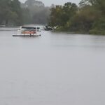
- Deal Lake
-
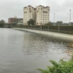
- Norwood Ave. Bridge